
About Us
Loima Constituency
Loima Constituency was established following electoral boundary delimitation in the year 2012 by being curved from the larger Turkana Central Constituency. It borders with Uganda to the West, Turkana Central to the East, Turkana West to the North West, Turkana North to the North, Turkana South to the South and Pokot North of West Pokot to the South West.
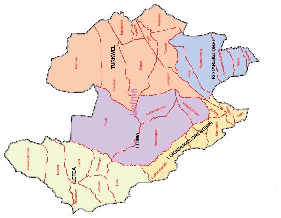
It is one of the six constituencies that make up Turkana County. It comprises one sub county headquartered at Lorugum Center and four Wards namely; Turkwell, Lobei - Kataruk, Loima, and Lokiriama - Lorengkippi.
Loima Constituency is 9,113.3 Kilometer Squared being the third smallest constituency in Turkana County after Turkana Central and Turkana South. It has a population of 107,795 people (54,341 Male and 53,453 Female) and a population density of 12 people per kilometer squared according to the 2019 Kenya Population and Housing Census .
The main economic activities are pastoralism, agro - pastoralism, small scale businesses, precious stones harvesting, charcoal burning, remittances from employed relatives, casual labour, cash transfers by Hunger Safety Net Programme (HSNP) and Non-governmental organizations, dry land farming, wild fruits and limited formal employment.
OUR VISION
The Leading Constituency in Sustainable and Inclusive Development in Kenya
OUR MISSION
To Transform Livelihoods through Equitable and Sustainable Utilization of Resources
OUR CORE VALUES
Commitment and team work
Advocacy for constituents Participation and involvement
Transparency and Accountability
Professionalism and Integrity
Neutrality and Objectivity
Timeliness and Excellence
Access NG-CDF Information on your Mobile


County Assembly Wards in Loima Constituency :
TurkwelWard
- County Assembly Ward No.:
- County Assembly Ward Name: Turkwel
- County Assembly Ward Population (Approx.):
- County Assembly Ward Area In Sq. Km (Approx.):
- County Assembly Ward Description: comprises part of
Lokiriama/Lorengippi Ward
- County Assembly Ward No.:
- County Assembly Ward Name: Lokiriama/Lorengippi
- County Assembly Ward Population (Approx.):
- County Assembly Ward Area In Sq. Km (Approx.):
- County Assembly Ward Description: comprises part of
Lobei/Kotaruk Ward
- County Assembly Ward No.:
- County Assembly Ward Name: Lobei/Kotaruk
- County Assembly Ward Population (Approx.):
- County Assembly Ward Area In Sq. Km (Approx.):
- County Assembly Ward Description: comprises part of
Loima Ward
- County Assembly Ward No.:
- County Assembly Ward Name: Loima
- County Assembly Ward Population (Approx.):
- County Assembly Ward Area In Sq. Km (Approx.):
- County Assembly Ward Description: comprises part of